Product Description
- Number of Channels---------220 channels
- Tracked Signals:
---GLONASS: L1C/A, L1P, L2C/A(Glonass M only), L2P
Code differential GNSS positioning(DGPS)
Horizontal ..........................................±0.25 m + 1 ppm RMS
Vertical ............................................. ±0.50 m + 1 ppm RMS
SBAS differential positioning accuracy......... typically <5 m
Static GNSS surveying
Horizontal ..................................... ±3.0 mm + 0.5 ppm RMS
Vertical ......................................... ±5.0 mm + 0.5 ppm RMS
Real Time Kinematic surveying[RTK]
Horizontal .................................... ±8 mm + 1 ppm RMS
Vertical ....................................... ±15 mm + 1 ppm RMS
Initialization time...................................typically < 8seconds
Initialization reliability..................................Typically > 99.9%
Hardware Physical
Size (W×H).................................................. 20.5 cm x 10 cm
Weight ..................................................... 1.47 kg with battery
Operating Temperature ...............................-45° C to +60° C
Storage Temperature ..................................-55° C to +85° C
Humidity.....................................................100%,condensing
Dust/Water Protection......IP67 at closing all connector caps. Protected agaist temporary immersion up to 1m depth.
Shock and vibration...................Designed to survive a 2.5m natural fall onto concrete.
Electrical
- Power 12 to 15V DC external power input with over-voltage protection
- Rechargeable, removable 7.4V,3Ah Lithium-ion battery
- Battery life :6-10 for 2 batteries from standard supply(varies with temperature and working mode)
- Button...... Double buttons
- LCD...... 12leds
- Voice.........support
GPRS antenna connector / UHF antenna connector
DC power input (5-pin) / RS232 and Data port (9-pin)
SIM card slot /1 x Micro SD slot
Communications and Data Storage
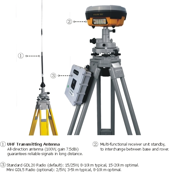
External Radio
Frequency.....................................................410~470MHz
Transmitting power..........................5W /35W adjustable
Working range...................................................... 8~30km
Cellular...................WCDMA3.5G,GPRS/EDGE(option CDMA2000/ EVDO 3G)
Bluetooth................Bluetooth 2.1+EDR/ Bluetooth 4.0 BLE
Data storage:
Internal Memory : 4 GB
External Memory: Micro SD card (Max. 32GB)
Data Formats:
1Hz positioning output, up to 20Hz
CMR, CMR+, RTCM 2.3, RTCM 3.0, RTCM 3.1, RTCM 3.2
Our Services
1) We provide not only high cost-efficiency surveying instruments,
2) but also professional surveying solutions and strong technical maintaining supports.
3) Make sure Quality Verified & recalibrated before each shipment.
4) Fast Delivery, stocked in Guangzhou.
5) Professional Export & Import Service.
6) One-year warranty period of surveying equipments.
For the payment, it varies from by different countries and regions!
With 10 years surveying equipments & maintaining service working experience, Geoland Team Established in 2007, has a strong capacity of helping our clients with their surveying instruments demands & Solutions.
Our products scope covers a full range of geographic surveying instruments & variety of compatible surveying accessories. Includes RTK GPS/GNSS system, total stations, theodolites, automatic/digital levels, Laser Levels, laser distance meters, distance measuring wheels, surveying prisms, tripods, poles, staffs, rods, batteries, chargers, data cables etc.